


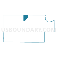
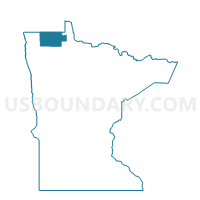
Jadis Unorganized Voting District, Roseau County, Minnesota
About
Outline

Summary
| Unique Area Identifier | 604144 |
| Name | Jadis Unorganized Voting District |
| County | Roseau County |
| State | Minnesota |
| Area (square miles) | 25.85 |
| Land Area (square miles) | 25.83 |
| Water Area (square miles) | 0.01 |
| % of Land Area | 99.95 |
| % of Water Area | 0.05 |
| Latitude of the Internal Point | 48.95860950 |
| Longtitude of the Internal Point | -95.82925600 |
Maps

Graphs
Select a template below for downloading or customizing gragh for Jadis Unorganized Voting District, Roseau County, Minnesota


Neighbors
Neighoring Voting District (by Name) Neighboring Voting District on the Map
- Dieter Twp. Voting District, Roseau County, MN
- Jadis Twp. Voting District, Roseau County, MN
- Norland/Spruce Valley Unorg. Voting District, Roseau County, MN
Top 10 Neighboring County Subdivision (by Population) Neighboring County Subdivision on the Map
- Jadis township, Roseau County, MN (568)
- Dieter township, Roseau County, MN (148)
- North Roseau UT, Roseau County, MN (139)